|
|
Outlooks
Monitoring and Data
About Us
Contact Us
|
| |
|
|
HOME > Expert Assessments > Drought Information > Seasonal Drought Outlook
|
| |
| |
| |
 |
| |
| |
|
| (Click on image to enlarge) |
| |
PDF Version of Seasonal Drought Outlook Graphic  |
| |
|
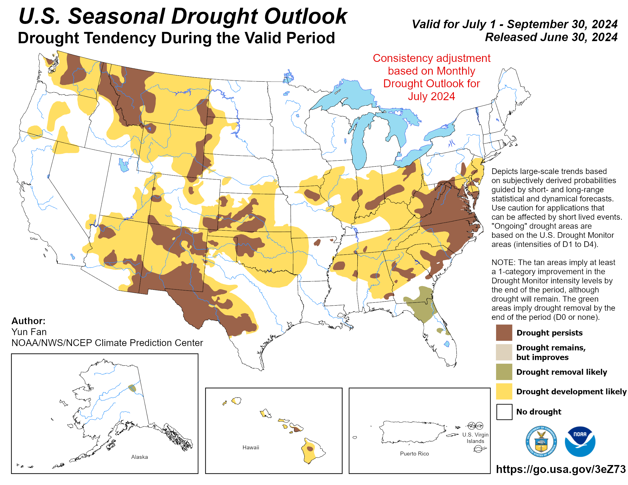
The main changes in the updated Seasonal Drought Outlook (SDO) compared to the original one released about two weeks ago are focused on two areas; the Lower Mississippi Valley and the Upper Mississippi Valley. For the first region, the original SDO depicted improvement over much of the region outside of the Arklatex (where drought persistence was favored), with odds favoring below-normal precipitation in JAS 2026 over western parts of the area including the Arklatex. However, the Monthly Drought Outlook (MDO) and the latest CPC precipitation outlook for July are not as optimistic, with drought persistence and mostly EC in the precipitation outlook. Though some improvement may occur east of the Arklatex in August and September, the overall signal favors drier conditions and a better chance for drought persistence. For the second region, the Upper Mississippi Valley, the SDO released on June 18th supported a pattern of continuing drought along with new development. The corresponding precipitation pattern called for Equal Chances in this area. The MDO indicates some short-term relief is likely, with a return to drier conditions by mid to late July. The July precipitation outlook calls for a mix of Below normal and EC. Accordingly, the SDO was adjusted in this region to reflect short-term improvement over the Upper Mississippi Valley, with drought development considered most likely across the western Dakotas.
|
|
Updated Seasonal Assessment -
The main changes in the updated Seasonal Drought Outlook (SDO) compared to the original one released about two weeks ago are focused on two areas; the Lower Mississippi Valley and the Upper Mississippi Valley. For the first region, the original SDO depicted improvement over much of the region outside of the Arklatex (where drought persistence was favored), with odds favoring below-normal precipitation in JAS 2026 over western parts of the area including the Arklatex. However, the Monthly Drought Outlook (MDO) and the latest CPC precipitation outlook for July are not as optimistic, with drought persistence and mostly EC in the precipitation outlook. Though some improvement may occur east of the Arklatex in August and September, the overall signal favors drier conditions and a better chance for drought persistence. For the second region, the Upper Mississippi Valley, the SDO released on June 18th supported a pattern of continuing drought along with new development. The corresponding precipitation pattern called for Equal Chances in this area. The MDO indicates some short-term relief is likely, with a return to drier conditions by mid to late July. The July precipitation outlook calls for a mix of Below normal and EC. Accordingly, the SDO was adjusted in this region to reflect short-term improvement over the Upper Mississippi Valley, with drought development considered most likely across the western Dakotas.
|
|
Latest Seasonal Assessment -
Drought coverage and intensity across the contiguous United States decreased over the last two months, driven by a much wetter pattern over the southeastern quadrant of the nation. Despite these improvements, drought conditions continue to be fairly widespread, with almost half of the Lower 48 remaining in drought as of July 7. During the remainder of July through the end of October, El Niño conditions are favored to have an increasing impact on climate anomalies. Enhanced monsoon moisture driven by warmer Pacific ocean temperatures favors widespread drought reduction across the Four Corners region and much of the Rockies, with short term forecasts also trending very wet. In contrast, a potential for hot, seasonably dry conditions may promote additional drought expansion across the Northwest. Drought development is also possible across the upper Midwest, where recent dryness has led to wildfire development across northern Minnesota. Across the East, seasonable wetness favors a gradual reduction in drought coverage, but a drier signal during August, and the potential for reduced Atlantic tropical cyclone activity, may make drought slower to ease across portions of the Southeast, particularly across the Carolinas. Daily seabreeze convection across Florida may also not be sufficient to completely remove drought conditions that were very intense at the onset of the summer rainy season. No drought is currently in place or forecast to develop across Alaska and Hawaii, with forecast guidance trending wet across both states. In contrast, drought conditions have been steadily expanding across Puerto Rico and the US Virgin Islands, and suppressed convection is likely to further aggravate impacts.
Forecaster: Adam Allgood
Next Seasonal Drought Outlook issued: August 20, 2026 at 8:30 AM EDT
Seasonal Drought Outlook Discussion
|
|
|
|