ATTENTION: We would like to hear from you! Please provide your feedback and suggestions about these outlooks by taking the customer satisfaction survey HERE.
Composite Map
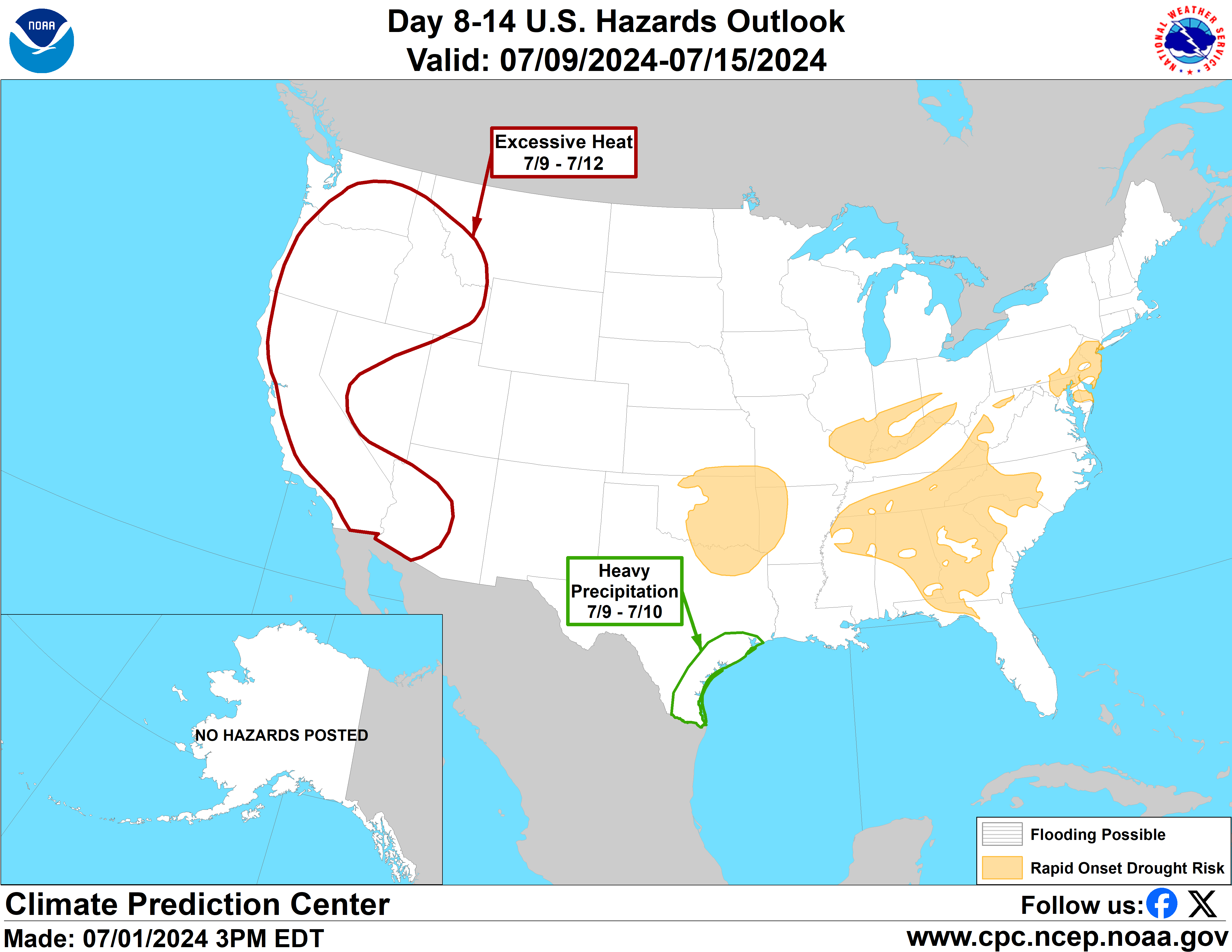
Day 8-14
Experimental Probabilistic Outlooks
Valid Wednesday July 23, 2025 to Tuesday July 29, 2025
US Hazards Outlook NWS Climate Prediction Center College Park MD 300 PM
EDT July 15 2025
Synopsis: Multiple models indicate stronger
mid-level high pressure across much of the contiguous U.S. (CONUS) during the
week-2 period compared to yesterday. The center of the mid-level high is
generally forecast across the Great Plains and Mississippi Valley, although
there are model differences regarding the specific location of where the center
is located and the intensity of this high. This pattern supports increased
chances of extreme heat to many areas east of the Rockies.
Hazards
Slight risk of extreme heat for many parts of
the CONUS east of the Rockies, Wed-Tue, Jul 23-29.
For Wednesday July 23 - Tuesday
July 29: The GEFS, ECENS, and CMCE ensemble means show greater positive
500-hPa height anomalies forecast across much of the CONUS compared to
yesterday. The ECENS and CMCE indicate areas of the Rockies with the greatest
height departures, with surface high pressure centered over the Southern Plains
and Lower Mississippi Valley. The GEFS, however, shows lower height departures
that are spread broader, extending to the Interior West.
The anticipated mid-level ridging elevates chances for above-normal
temperatures for much of the CONUS near the climatologically hottest time of
year for much of the country, excluding the West Coast. A slight risk of
extreme heat is designated for many areas east of the Rockies throughout the
entirety of week-2. This risk area is primarily based on the ECENS and CMCE
model guidance and tools based on good agreement between the two, and the ECENS
being favored in the mean week-2 temperature tools. Multiple calibrated heat
tools and Probabilistic Extremes Tools (PETs) show at least a 20% chance of air
temperatures and heat index values exceeding the 90th percentile across areas
east of the CONUS. Multiple tools indicate the greatest likelihood of extreme
heat across the Lower and Middle Mississippi and Tennessee Valleys and
Southeast during the middle of week-2. The National Blend of Models (NBM) show
near record daytime temperatures over the Tennessee Valley and near record
nighttime temperatures across many areas across the East.
Guidance from GEFS based tools continue to support a slight risk of extreme
heat for portions of the Interior West. However, the ECENS and CMCE height
pattern and signals for this heat potential are noticeably weaker. Due to high
uncertainty, no associated hazard is posted at this time but the area will be
monitored for potential addition of a hazard, if models can come into better
agreement.
Forecaster: Melissa Ou
$$
Please consult local NWS Forecast Offices for short range forecasts and region-specific information.