|
|
Forecast Tools
|
Verification
|
Related Outlooks
|
About Us
|
Contact Us
|
As of the May 19th, 2017, release, Week 3-4 outlooks precipitation outlooks are experimental, whereas the temperature outlooks are operational. Both are issued Friday between 3pm & 4pm Eastern Time.
|
|
|
HOME>
Outlook Maps>
Week 3-4 Outlooks
|
|
|
Week 3-4 Outlooks
|
Valid: 01 Aug 2026 to 14 Aug 2026
Updated: 17 Jul 2026
|
|
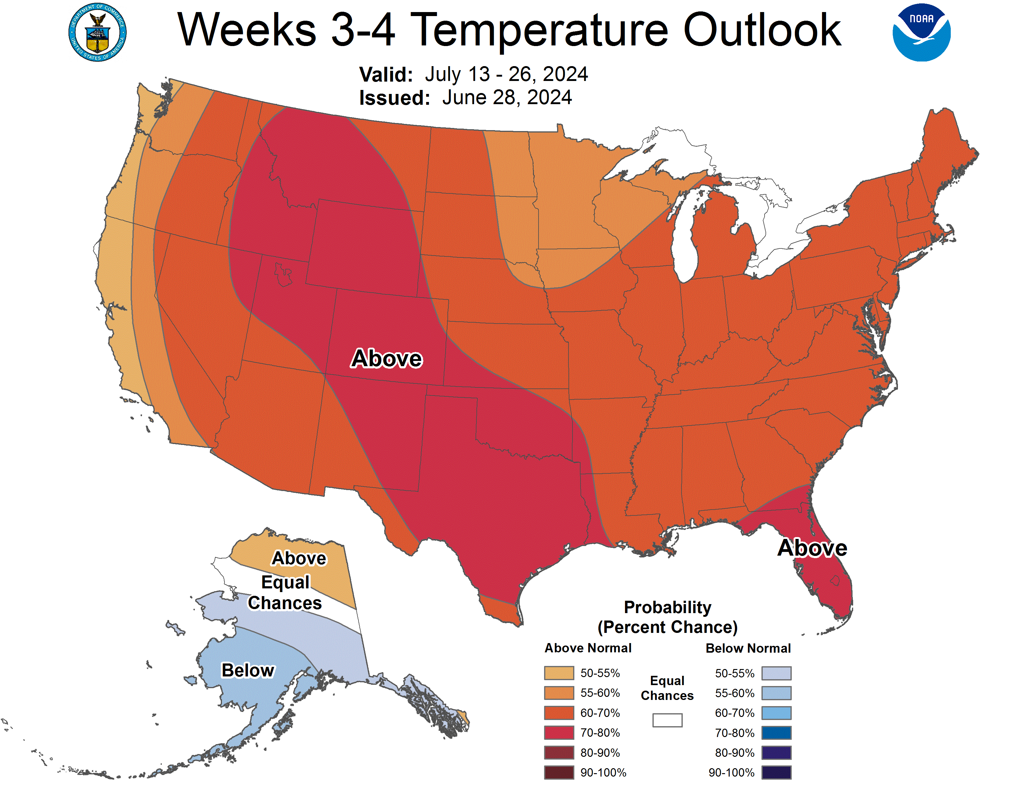
Temperature Probability
|
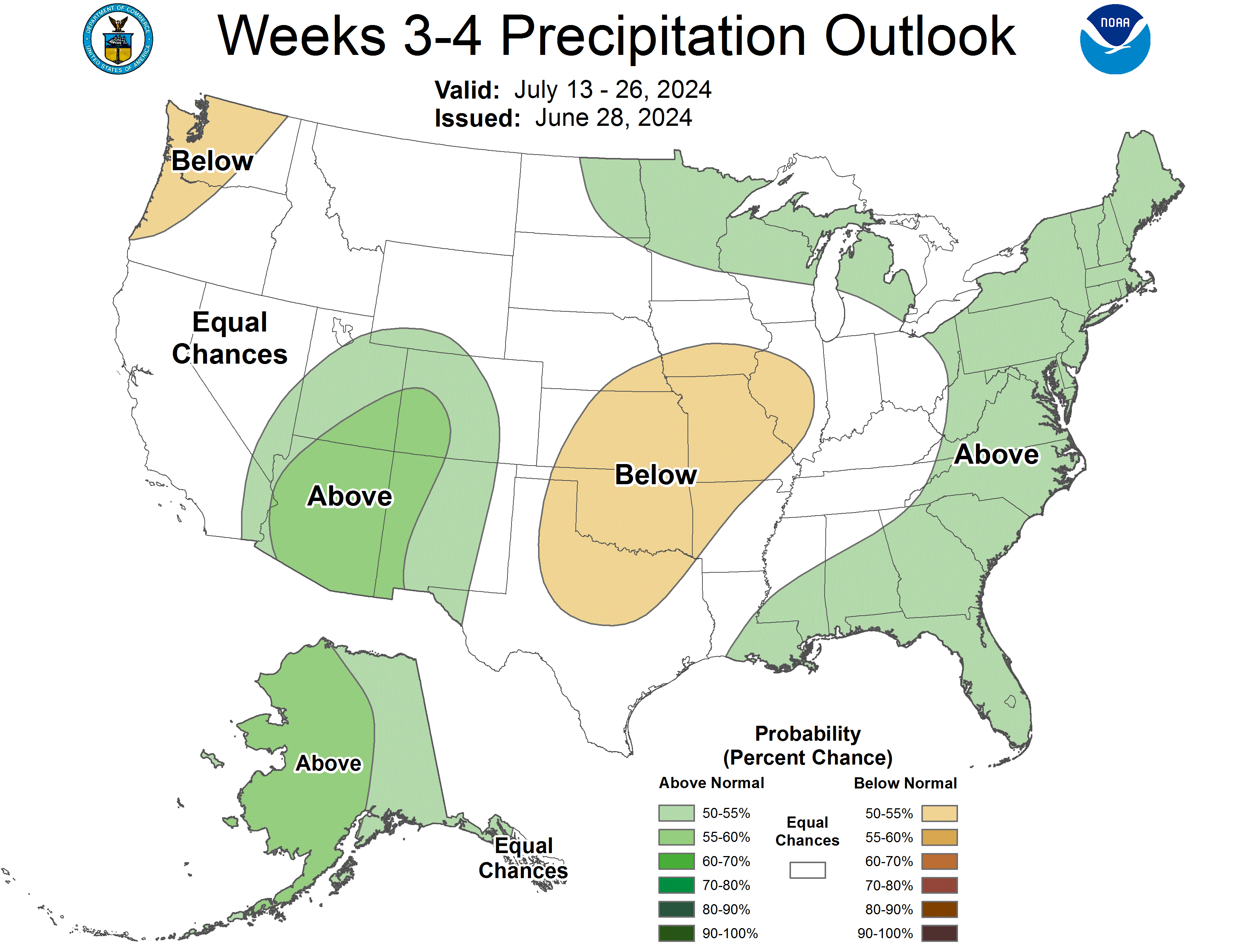
Precipitation Probability
|
Week 3-4 500-hPa Height Outlook
|
|
Click HERE for info about how to read Week 3-4 outlook maps
|
|
|
Prognostic Discussion for Week 3-4 Temperature and Precipitation Outlooks
NWS Climate Prediction Center College Park MD
300PM EDT Fri Jul 17 2026
Week 3-4 Forecast Discussion Valid Sat Aug 01 2026-Fri Aug 14 2026
During the summer months, the tropical Pacific climate variability typically has only a modest influence on the Week 3-4 Temperature and Precipitation Outlooks. This summer, however, presents an uncommon scenario due to the emergence of a strengthening El Niño, with Relative Niño 3.4 sea surface temperature (SST) anomalies exceeding 1 degree Celsius. Additionally, the equatorial Pacific outgoing longwave radiation pattern is favorable for the excitation of Rossby waves that could propagate to the extratropics, an occurrence more typical of winter than summer. Consequently, these factors, alongside dynamical models, will also be considered in the forecast.
The manual blend of statistical and dynamical (CFS, ECMWF, GEFS, and JMA) tools indicates broad, weak positive geopotential height anomalies extending from southern Alaska into the northwestern and northern Plains, with neutral heights across the remainder of the Contiguous United States (CONUS). This blend reflects conflicting model signals, likely related to the El Niño footprint. While both CFS and GEFS (and to a lesser degree, ECMWF) depict anomalous ridging across much of the CONUS, the JMA remains a clear outlier. The JMA guidance features an amplified wave-train pattern reminiscent of summer El Niño circulation, showing anomalous ridging over Alaska paired with anomalous troughing over the Aleutians, central Plains, and Midwest. Meanwhile, the ECMWF shows neutral to below-normal heights over the Great Lakes, hinting at a weak El Niño-like signal that is potentially drowned out by noise. Heavily influenced by the El Niño signal, the multiple linear regression (MLR) tool (incorporating ENSO, MJO, and trend) aligns more closely with the JMA.
The Week 3-4 Temperature Outlook tilts toward above normal probabilities for the western, southern, and eastern sections of the CONUS. This outlook is well-supported by both statistical and dynamical model guidance, particularly in the western CONUS where anomalous ridging is present. Conversely, dynamical models exhibit lower consistency regarding the temperature forecast in the interior of CONUS. Within these areas, neutral-to-negative height anomalies are depicted by the JMA and ECMWF, suggesting below-normal temperatures, particularly in the JMA model.The MLR tool further promotes these below-normal temperature probabilities, notably in regions of the Mississippi Valley consistent with El Niño. However, because the GEFS and CFS predict warm temperatures, these conflicting signals result in a forecast of Equal Chances (EC) of above, near, or below normal temperatures for the interior.
The Week 3-4 Precipitation Outlook continues to indicate an enhancement of the desert monsoon with above normal precipitation favored for the Southwest extending into the Great Basin. Model guidance agreement also supports a dry signal for southern Texas. Elsewhere, however, models are inconsistent regarding any precipitation. While certain model guidance points toward elevated precipitation probabilities in the Southeast, there is disagreement over the exact location of this wet signal, and the GEFS indicates a more widespread dry pattern. Consequently, EC of above, near, or below normal precipitation is forecast for the Southeast as well as the remainder of the CONUS.
For Alaska, the anomalous circulation pattern is generally weak though geopotential height anomalies are slightly above normal in the south and below normal in the north. The dynamical model guidance predicts near to slightly below normal temperatures for the North Slope. Additional considerations from El Niño and abnormally high sea ice along the north coast of Alaska further support the below normal temperature forecast. The North Slope also tilts toward above normal precipitation.
Model guidance suggests that the emerging El Niño signal and associated increase in SSTs in the tropical Pacific are favored to impact the Hawaiian Islands. There is strong support for a tilt toward above normal temperatures across the islands. Model guidance also consistently favors above normal precipitation.
Forecaster: Laura Ciasto
The next week 3-4 outlook will be issued on Friday, Jul 24, 2026
These outlooks are based on departures from the 1991-2020 base period
These are three category outlooks consistent with what is currently used for the monthly and seasonal forecasts.
The shading on the temperature map depicts the most favored category, either above-normal (A), below-normal (B), or near-normal (N) with the solid lines giving the probability ( >33%) of this more likely category (above, below, or near).
The shading on the precipitation map depicts the most favored category, either above-median (A), below-median (B), or near-median with the solid lines giving the probability ( >33%) of this more likely category (above, below, or near).
In areas where the likelihoods of 2-week mean temperatures and accumulated precipitation amounts are similar to climatological probabilities, equal chances (EC) is indicated.
|
|
|
|
An ASCII (w/ HTML markup tags) text version of the written forecast is available.
|
|
|


