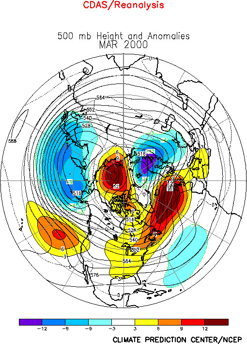
| 1. Northern Hemisphere The circulation during March featured above-average
heights across the east-central North Pacific, over the polar region, and in the area
extending northeastward from the eastern half of North America to northern Europe (Fig. E9). The circulation also featured below-average heights
across the high latitudes of the North Pacific, over the lower latitudes of the central
North Atlantic and over eastern Europe/ western Russia.
In the subtropics, there was again considerable symmetry of the upper-level circulation
anomalies in both hemispheres (Fig. T22, bottom). The most
notable aspect of this anomaly pattern has been a persistent pattern of anticyclonic
circulation anomalies extending eastward in the Northern Hemisphere from the Atlantic
Ocean to Asia and in the Southern Hemisphere from the Atlantic Ocean eastward to
Australia. This pattern was also prominent throughout 1999 in association with ongoing La
Ni�a conditions, and is a leading mode of atmospheric variability on both the interannual
and interdecadel time scales.
a. North America
Above-average heights covered the eastern half of the United States during March, in
association with an overall weakening and eastward shift of the mean Hudson Bay Trough.
This trough typically extends southward from Hudson Bay to the Great Lakes region of the
United States at this time of the year. These conditions were associated with anomalously
zonal flow across the United States, and with a markedly reduced strength of northwesterly
flow over the north-central U.S. and Canada. As a result, surface temperatures were well
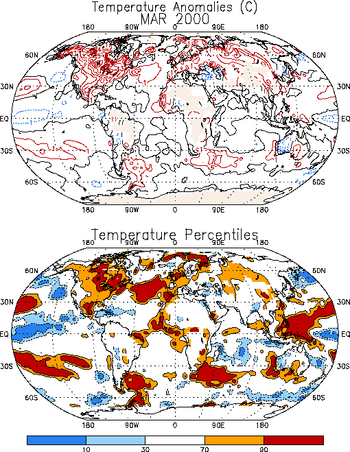
above-average across Canada and most of the United States during the month (Fig. E1), with values exceeding the 90th percentile
over large portions of central Canada and the northeastern quadrant of the United States (Fig. E1, bottom). Elsewhere, temperatures averaged above the 70th
percentile over most of the remaining portion of Canada, and throughout the United States
east of the Continental Divide. Anomalously warm temperatures also covered most of Mexico
during the month.
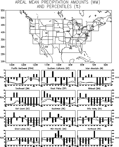
The eastern half of the United States also recorded below-average rainfall during the
month (Fig. E3), with large portions of this area having
recorded below-normal rainfall since last summer. During this 9-month period exceptionally
dry conditions have prevailed in the Great Plains region, the Midwest, and the Great Lakes
area (Fig. E5). The Midwest and Great Lakes regions have
recorded below-average rainfall in every month since July 1999. Considerable dryness has
also prevailed in the Gulf Coast, the mid-Atlantic and Northeast regions since November
1999, with longer-term precipitation deficits in these latter two regions also extending
back to July 1999. In the Great Plains area, March was the first month since July 1999 in
which near-average rainfall was recorded.
b. Europe/ Asia
Most of Europe experienced milder-than-average temperatures during March (Fig. E1), with surface temperatures averaging above the 70th
percentile across Europe. In northwestern France and portions of Great Britain
temperatures averaged above the 90th percentile during the month. This
anomalous warmth was associated with an overall northward shift of the main belt of
westerlies (Fig. E11, left) and main storm track (Fig. E13, left) to southern Scandinavia.
2. Southern Hemisphere
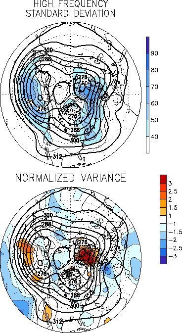
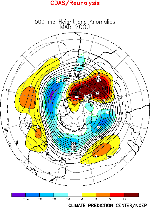
The Southern Hemisphere circulation during March (Fig. E15)
featured above-normal heights over southeastern Australia and New Zealand, over the middle
latitudes of the central South Pacific and central Indian Ocean, and over the high
latitudes of the central South Atlantic. It also featured below-normal heights over the
high latitudes of the South Pacific and Indian Ocean. Much of the central latitudes have
experienced above-average heights for over a year, in association with an extremely
persistent pattern of anticyclonic circulation anomalies in both hemispheres extending
from the Atlantic ocean eastward to Australasia (See Northern Hemisphere Highlights
above).
In recent months southeastern Africa has recorded significantly above-average rainfall
in association with this anomalous circulation. This excessive rainfall has occurred
during the region’s rainy season, and has resulted in large-scale flooding across
much of central Mozambique. A Tropical Cyclone also impacted Mozambique during the month,
which exacerbated flooding conditions in that area. A second Tropical Cyclone (TC Hudah)
also impacted the coastal areas of central and northern Mozambique in early April. This
system made a direct hit on northeastern Madagascar in early April, destroying the towns
of Antalaha and Cap Est.
The above-average rainfall during January-March in southeastern Africa was associated
with an anomalous large-scale circulation pattern that featured 1) enhanced low-level
easterly winds across the central Indian Ocean in association with an amplification and
poleward shift of the Mascarene High (Fig. T20, bottom),
2) an anomalous low-level circulation center over south-central Africa, with anomalous
westerly winds across southern Africa between 10�-20�S, and 3) anomalous upper-level
easterly winds in association with a poleward extension of the subtropical high (Fig. T22) and a corresponding poleward shift of the main
upper-level westerly winds to south of the continent (Fig. T21).Overall,
these conditions were associated with low-level confluence extending southwestward along
the Mozambique coast, and with anomalous large-scale convergence across southeastern
Africa and the Mozambique Channel. Collectively, these conditions represented an enhanced
monsoonal circulation over southeastern Africa. |
