HOME> Expert Assessments>Hazards Outlook
For 3-7 day hazards see Weather Prediction Center's: WPC 3-7 Day Hazards
U.S. Week-2 Hazards Outlook - Made April 11, 2025 | About the Hazards Outlook
ATTENTION:
We would like to hear from you! Please provide your feedback and suggestions about these outlooks by taking the customer satisfaction survey HERE.


Map data © OpenStreetMap contributors, CC-BY-SA |
Zoom In
Zoom Out
| Composite Map |
Experimental Probabilistic Outlooks |
 |
Valid Saturday April 19, 2025 to Friday April 25, 2025
US Hazards OutlookNWS Climate Prediction Center College Park MD
300 PM EDT April 11 2025
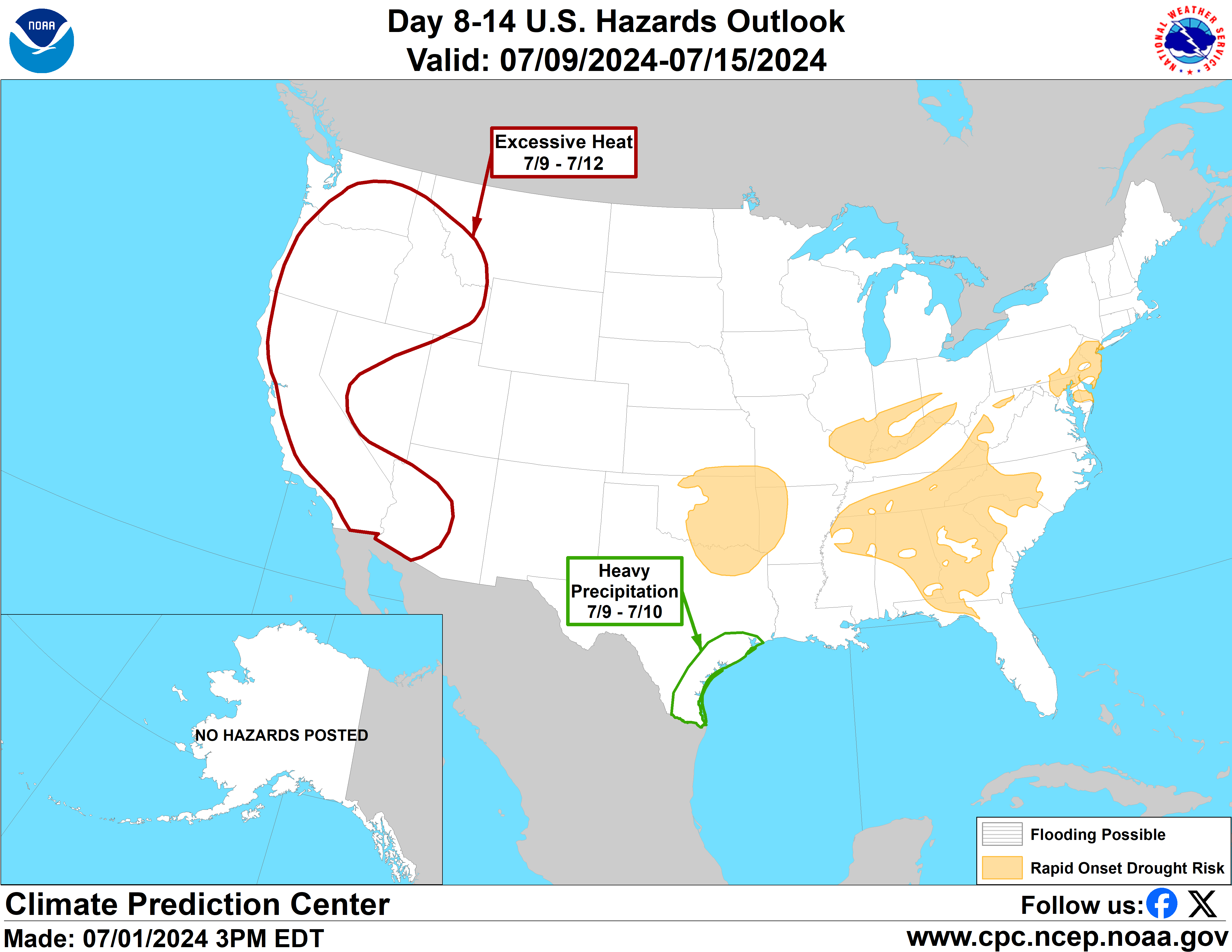
Synopsis: A shot of much below normal temperatures bringing frost and freeze chances to portions of the Mid-Atlantic is possible at the onset of week-2. Associated with this cold air is an area of surface low pressure forecast to develop in the Northeast and southeastern Canada bringing increased chances for high winds to parts of the region. By the middle of the period, an area of mid-level low pressure over the West will begin to bring increased chances for heavy precipitation and high winds to portions of the south-central contiguous U.S. (CONUS). Flooding remains possible into week-2 along portions of the Middle and Lower Mississippi River.
Hazards
- Slight risk of much below normal temperatures for portions of the Great Lakes, Ohio, Tennessee, and Middle Mississippi Valley, Southeast, and Mid-Atlantic, Sat-Sun, Apr 19-20.
- Slight risk of high winds for the Northeast, Sat-Sun, Apr 19-20.
- Slight risk of heavy precipitation for portions of the Central and Southern Plains and Middle and Lower Mississippi Valley, Sun-Wed, Apr 20-23.
- Slight risk of high winds for portions of the Central and Southern Plains, and Southern Rockies, Sun-Wed, Apr 20-23.
- Flooding possible for the Middle and Lower Mississippi, and lower Ohio Rivers.
For Monday April 14 - Friday April 18: WPC Days 3-7 U.S. Hazards
For Saturday April 19 - Friday April 25: A mid-level trough is forecast to be over the northeastern CONUS at the onset of the period with an associated surface low pressure system over the Maritime Provinces of Canada. This surface low pressure has grown stronger in the ensemble guidance today relative to prior forecasts. Therefore, a slight risk of high winds remains posted for this feature for Apr 19-20. The additional strength of this system increases the cold air advection into the eastern CONUS bringing a broader risk for another shot of much below normal temperatures into portions of the East early in week-2. Temperatures are forecast by deterministic model runs and the Probabilistic Extremes Tools (PETs) and some ensemble guidance to fall below 40 deg F. across portions of the Middle Mississippi, Ohio, and Tennessee Valleys, Southern Great Lakes, Mid-Atlantic, and into parts of the upper Southeast early in week-2, increasing chances for frost and freezes. Therefore, an associated much below normal temperatures hazard is forecast for Sat-Sun, Apr 19-20.
A mid-level trough is forecast to develop across the West during the first half of the week-2 period. This trough increases the chances for a lee-side cyclogenesis in the Southern and Central Plains. Further, the surface pattern from the GEFS, ECENS, and Canadian ensemble all support strong return flow off of the Gulf. The raw ensemble guidance remains diffuse with relatively low rainfall amounts across a fairly broad region of the Plains and Mississippi Valley. However, both the GEFS and ECENS PETs highlight this area for precipitation exceeding the 85th climatological percentile. Further, deterministic guidance from the GFS, ECENS, and EC-AIFS all support development of precipitation and winds across this region sometime during the week-2 period. While uncertainty remains high on timing and placement, the guidance suggests development of enhanced precipitation at some point during the period. Scattered flash flooding may be a concern in these areas as precipitation is likely to be convective in nature. Therefore, a slight risk of heavy precipitation is forecast for the Central and Southern Plains, and Middle and Lower Mississippi Valley for Apr 20-23. Secondly, a slight risk of high winds is forecast for the high Central and Southern Plains and parts of the Southern Rockies for the same period.
In the central CONUS, given the copious antecedent rainfall and recurring flooding concerns in this region, a flooding possible hazard remains posted for portions of the lower Ohio, Middle and Lower Mississippi Valleys due to the potential for new and renewed rises in river levels. While main channels are already very high, and thus likely won’t respond too much to additional precipitation, tributaries and streams will be more susceptible to renewed flooding or flash flooding if additional rainfall occurs.
In Alaska, as spring continues and daily incoming solar radiation flux totals increase, ice-bound rivers will begin to break up. There is no associated hazard posted at this time but this situation will be closely monitored in the coming days and weeks as conditions can quickly change, leading to the potential for ice jams and associated flooding.
Forecaster: Ryan Bolt
$$ Please consult local NWS Forecast Offices for short range forecasts and region-specific information.
Resources
Week-2 Probabilistic Extremes Tool
GFS Ensemble Forecasts