HOME> Expert Assessments>Hazards Outlook
For 3-7 day hazards see Weather Prediction Center's: WPC 3-7 Day Hazards
U.S. Week-2 Hazards Outlook - Made April 24, 2025 | About the Hazards Outlook
ATTENTION:
We would like to hear from you! Please provide your feedback and suggestions about these outlooks by taking the customer satisfaction survey HERE.
| Composite Map Day 8-14 |
Experimental Probabilistic Outlooks |
 |
Valid Friday May 02, 2025 to Thursday May 08, 2025
US Hazards OutlookNWS Climate Prediction Center College Park MD
300 PM EDT April 24 2025
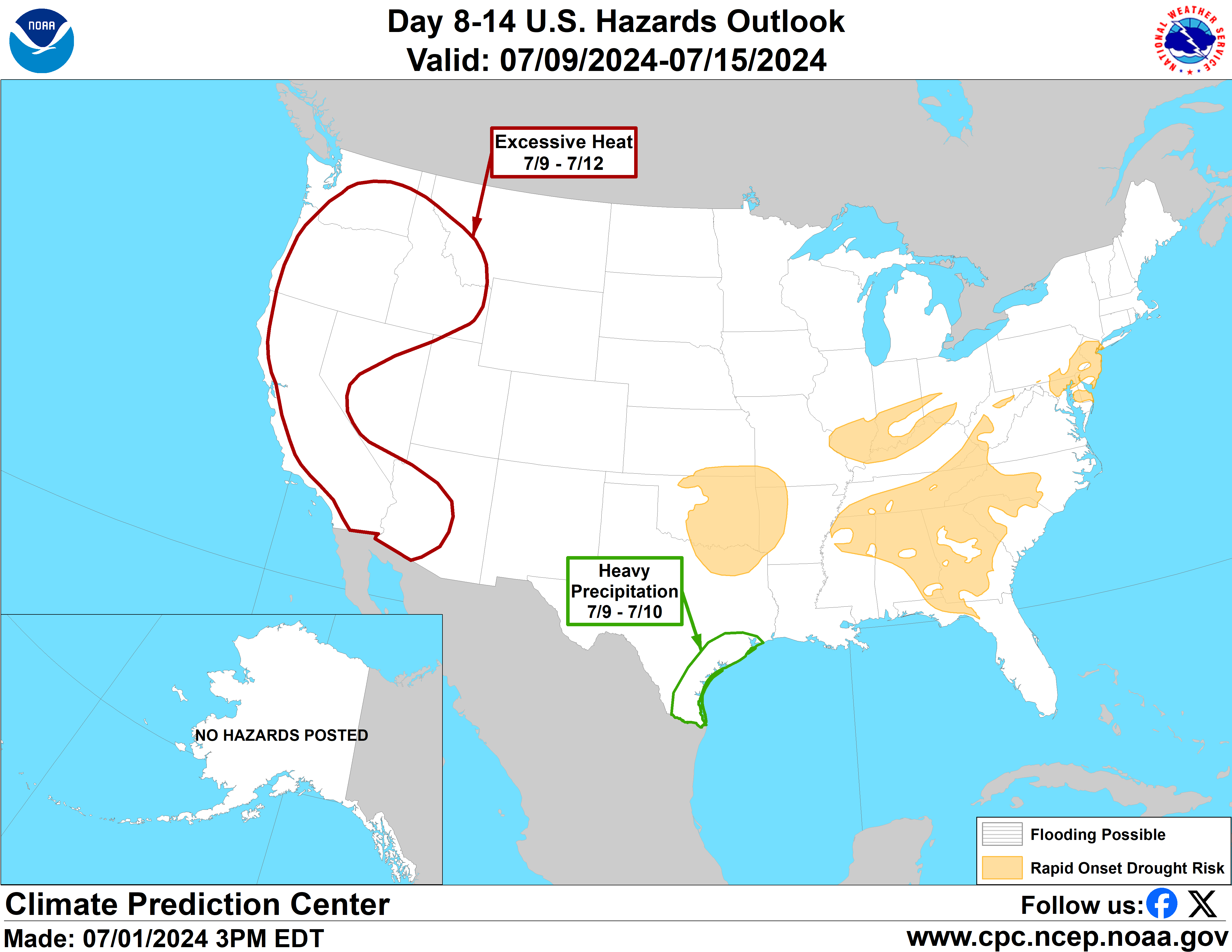
Synopsis: At the outset of week-2 surface low pressure is forecast to be near New England, with a trailing cold front extending across the east-central contiguous U.S. (CONUS) and the Southern Plains. This front is forecast to become stationary, which favors enhanced chances of heavy precipitation and thunderstorms across portions of this region continuing through much of week-2. Broad mid-level high pressure is forecast to develop across the CONUS later in week-2, favoring increased chances for above-normal temperatures over many areas.
Hazards
- Slight risk of heavy precipitation for portions of the Southern and Central Plains, and the Lower Mississippi Valley, Fri-Tue, May 2-6.
- Possible flooding for the Lower Mississippi River.
For Sunday April 27 - Thursday May 01: WPC Days 3-7 U.S. Hazards
For Friday May 02 - Thursday May 08: Late in week-1, surface low pressure is forecast to track across the Great Lakes area, with an associated trailing cold front draped across the east-central CONUS, serving as a focus for continued increased chances of heavy precipitation and thunderstorms. This front is expected to stall very early in week-2, with the heavier precipitation favored across portions of the Southern and Central Plains, and the Lower Mississippi Valley, where a slight risk of heavy precipitation is posted for May 2-6. This means there is at least a 20 percent chance of rainfall amounts exceeding the 85th climatological percentile and 1-inch. This slight risk area is supported by the Probabilistic Extremes Tool (PET) precipitation guidance from primarily the ECENS solution (and to a lesser degree from the GEFS and CANM), and by raw 0z ECENS precipitation forecasts. The raw 0z ECENS precipitation forecasts are more bullish than the other model guidance and would support a moderate risk of heavy precipitation for portions of this region. However, the GEFS and CANM solutions are somewhat different today, which precludes the posting of a moderate risk area. If the GEFS comes on board with the ECENS tomorrow, a moderate risk may be needed. Compared to yesterday, there is a slight westward and northward displacement of the heavy rainfall area over the south-central CONUS.
A possible flooding hazard remains posted across the Lower Mississippi River given the potential for new and renewed rises in water levels during week-2 tied to any additional rainfall over the region associated with the stationary front, as well as runoff from rainfall upstream. Main channels are already very high, and thus are unlikely to have large responses to additional precipitation. Regardless, tributaries and streams across this region (including the Southern Plains) will continue to be susceptible to renewed flooding or flash flooding if additional rainfall occurs. Late spring is the peak time for flash flooding in Texas, due in part to slow-moving thunderstorms.
Though no wind hazards are posted today, one area of concern is the Southwest, in advance of a mid-level, southern stream trough. Typically during the spring, as the deserts heat up, stronger winds rounding the base of approaching mid-level troughs are mixed down to the surface resulting in very gusty winds that occasionally produce significant damage. The ECENS and GEFS PETs depict wind speeds of at least 20 mph in parts of the Southwest, which may be underdone given the inherent nature of ensemble smoothing.
A cold front moving off the Northeast coast early in week-2 favors a reduction in temperatures over the Great Lakes and Northeast. The ECENS PET still depicts parts of the southern Mid-Atlantic and Southeast to have at least a 40 percent chance maximum temperatures would exceed the 85th percentile on May 2, though today’s National Blend of Models (NBM) does not show near-record or record temperatures over the East. A general trend toward more broad ridging and a pattern typical of late-Spring is forecast to emerge over much of the CONUS later in week-2.
Troughing forecast across Alaska favors increased chances for increased onshore flow and above-normal precipitation over the southeastern part of the state, though forecasted precipitation amounts of 1-2 inches fall short of hazards thresholds. Below-normal temperatures forecast over many areas may favor a slight delay in seasonal river ice breakup. However, as temperatures continue to warm, the eventual river ice breakup may lead to ice jams and associated upstream flooding in the coming weeks.
Forecaster: Anthony Artusa
$$ Please consult local NWS Forecast Offices for short range forecasts and region-specific information.
Resources
Week-2 Probabilistic Extremes Tool
GFS Ensemble Forecasts