|
|
General Information
|
Forecast Tools
|
Verification
|
Related Outlooks
|
About Us
|
Contact Us
|
As of the May 19th, 2017, release, Week 3-4 outlooks precipitation outlooks are experimental, whereas the temperature outlooks are operational. Both are issued Friday between 3pm & 4pm Eastern Time.
|
|
|
HOME>
Outlook Maps>
Week 3-4 Outlooks
|
|
|
Week 3-4 Outlooks
|
Valid: 19 Jul 2025 to 01 Aug 2025
Updated: 04 Jul 2025
|
|
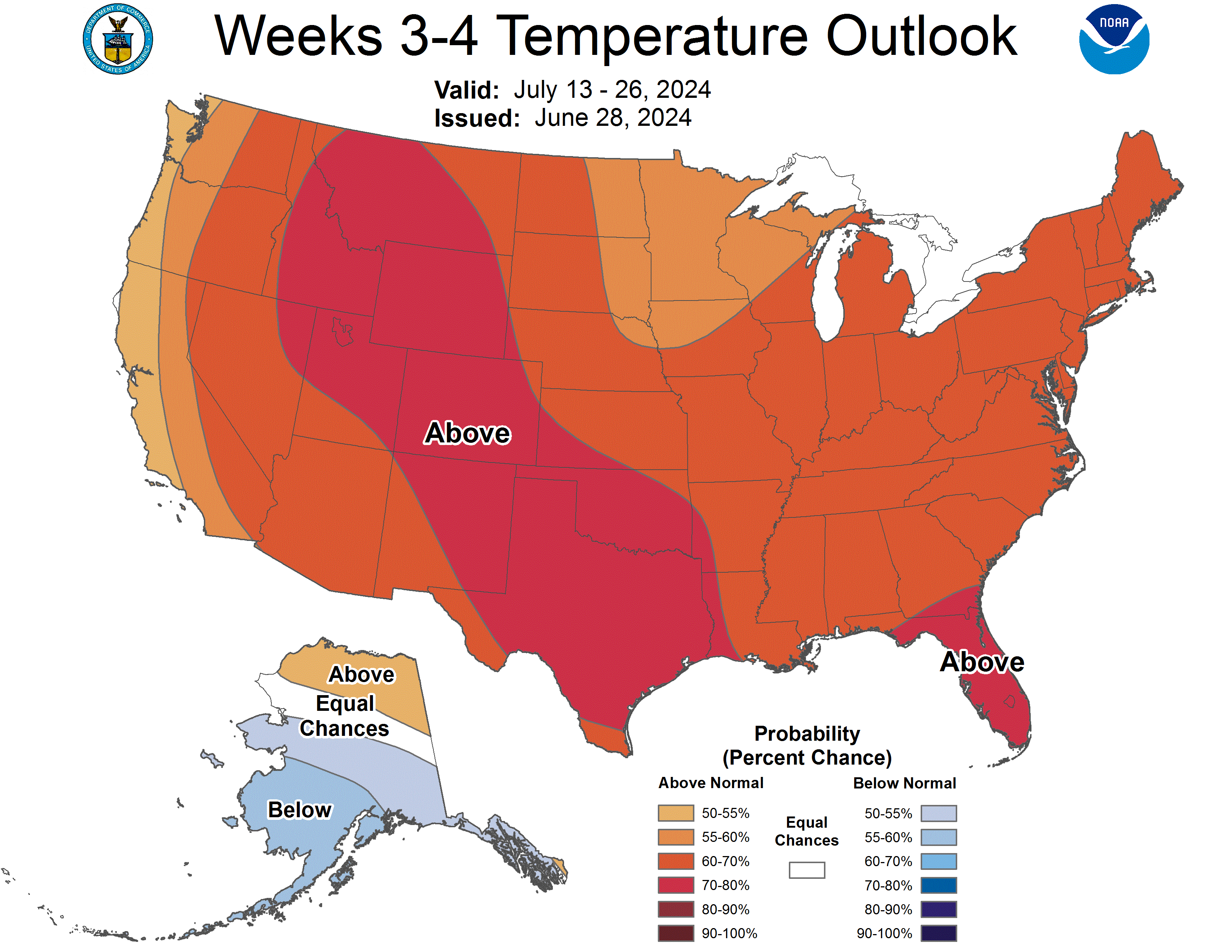
Temperature Probability
|
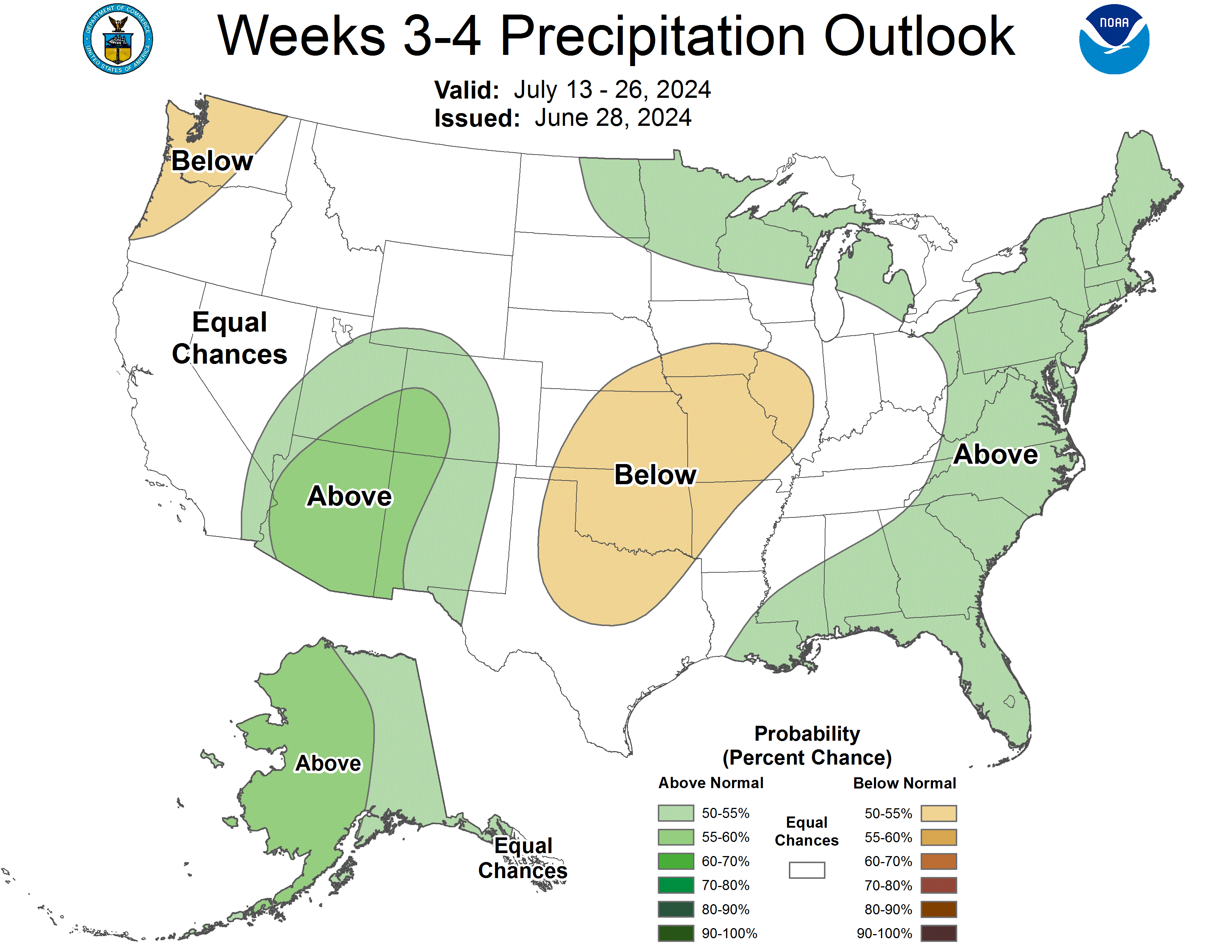
Precipitation Probability
|
Week 3-4 500-hPa Height Outlook
|
|
Click HERE for info about how to read Week 3-4 outlook maps
|
|
Prognostic Discussion for Week 3-4 Temperature and Precipitation Outlooks
NWS Climate Prediction Center College Park MD
300PM EDT Fri Jul 04 2025
Week 3-4 Forecast Discussion Valid Sat Jul 19 2025-Fri Aug 01 2025
ENSO-neutral conditions are currently present with equatorial sea surface temperatures (SSTs) near average across most of the Pacific Ocean. Low-level wind anomalies were easterly over the east-central and eastern Pacific. Upper-level wind anomalies were westerly over the eastern equatorial Pacific. The Madden Julian Oscillation (MJO) continues to be disorganized with other tropical modes continuing to prevail throughout the global tropics. The Weeks 3-4 Temperature and Precipitation Outlooks are based primarily on operational dynamical model guidance, including the GEFSv12, CFSv2, ECMWF, and JMA, as well as the predicted evolution of the pattern from the Week-2 forecast.
Dynamical model 500-hPa height anomaly forecasts during Weeks 3-4 show a fairly consistent evolution from Week-2 forecasts. A blend of the ECMWF and GEFSv12 500-hPa height pattern forecasts, plus a contribution from the Multivariate Linear Regression (MLR) height forecast based on the MJO RMM index, ENSO, and decadal trends, predicts anomalous ridging across the western contiguous United States (CONUS). Above average 500-hPa height anomalies are forecast over most of the CONUS. Above average height anomalies are also forecast over southern Alaska and the Gulf of Alaska, while a trough and below normal 500-hPa height anomalies are predicted over northern Mainland Alaska. Near normal 500-hPa heights are predicted over Hawaii.
Enhanced chances for above normal temperatures are predicted for most of the CONUS due to the anticipated mid-level ridging, generally near to above normal 500-hPa height anomalies, and supported by most of the dynamical temperature forecast tools and an experimental manual blend of GEFSv12, CFSv2, JMA, ECMWF, and the MLR tool. Probabilities favoring above normal temperatures reach 70% for parts of the Northern Great Basin, Northern Rockies, Northern Intermountain West, and the Northeastern CONUS. Equal chances (EC) of above and below normal temperatures are indicated across parts of northern Texas, Kansas, and Oklahoma, consistent with most of the temperature forecast tools. Above normal temperatures are favored over the Aleutians under above normal 500-hPa heights, while below normal temperatures are favored over parts of northern Mainland Alaska due a predicted trough and below normal 500-hPa heights.
The Weeks 3-4 Precipitation Outlook favors below median precipitation over parts of the Northern Rockies and the Northern Plains under above normal 500-hPa heights, supported by most of the dynamical precipitation forecast tools. A majority of the dynamical guidance favors a tilt toward near to above median precipitation over the eastern CONUS. Above median precipitation is also favored over parts of the Southwest monsoon region with predicted moisture flow into the region. Above normal precipitation chances are elevated over Alaska, consistent with most precipitation forecast tools.
Due to near normal sea surface temperatures and weak dynamical model signals, EC for above or below normal temperatures are forecast for much of the Hawaiian Islands with a slight tilt toward warmer than average temperatures for Kauai during Weeks 3-4. Above median precipitation is indicated for Kauai, Oahu and Maui, while EC of below, near, or above median precipitation is forecast for the Big Island, supported by most dynamical precipitation forecast tools.
| Temperature | Precipitation |
| FCST | FCST |
| Hilo | EC | EC |
| Kahului | EC | A55 |
| Honolulu | EC | A55 |
| Lihue | A55 | A60 |
Forecaster: Luke He
The next week 3-4 outlook will be issued on Friday, Jul 11, 2025
These outlooks are based on departures from the 1991-2020 base period
These are two category outlooks and differ from official current three category outlooks currently used for the monthly and seasonal forecasts.
The shading on the temperature map depicts the most favored category, either above-normal (A) or below-normal (B) with the solid lines giving the probability ( >50%) of this more likely category (above or below).
The shading on the precipitation map depicts the most favored category, either above-median (A) or below-median (B) with the solid lines giving the probability ( >50%) of this more likely category (above or below).
In areas where the likelihoods of 2-week mean temperatures and accumulated precipitation amounts are similar to climatological probabilities, equal chances (EC) is indicated.
|
|
|
|
An ASCII (w/ HTML markup tags) text version of the written forecast is available.
|
|
|


