HOME> Expert Assessments>Hazards Outlook
For 3-7 day hazards see Weather Prediction Center's: WPC 3-7 Day Hazards
U.S. Week-2 Hazards Outlook - Made May 17, 2024 | About the Hazards Outlook
ATTENTION:
For more information on the addition of the experimental Rapid Onset Drought hazard type to the Climate Prediction Center's 8-14 Day Hazards Outlook (Contiguous U.S. and Alaska), please click HERE.
To provide feedback, please answer the SURVEY.
| Composite Map Day 8-14 |
Experimental Probabilistic Outlooks |
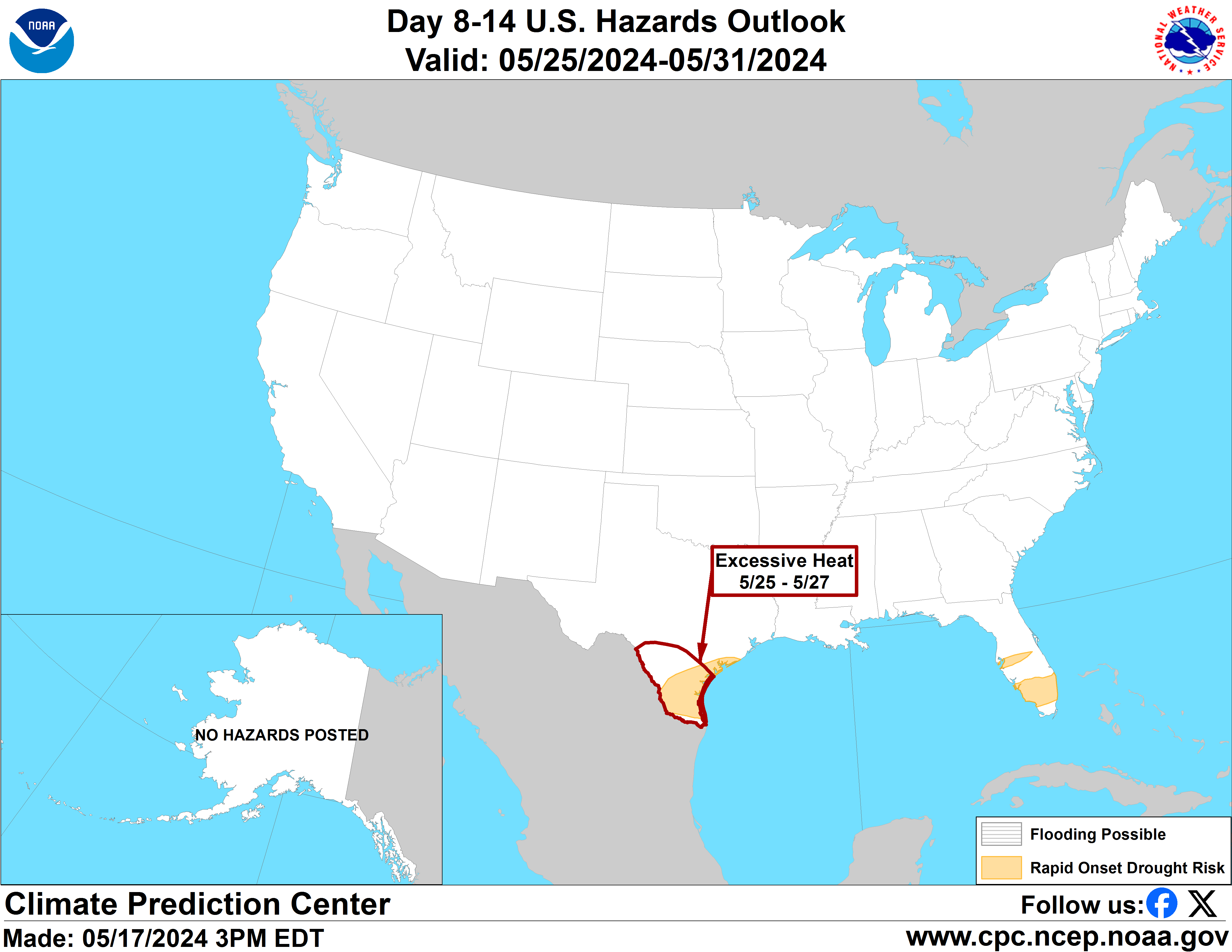 |
Valid Saturday May 25, 2024 to Friday May 31, 2024
US Hazards OutlookNWS Climate Prediction Center College Park MD
300 PM EDT May 17 2024
Synopsis: Mid-level high pressure is forecast across the Southern Tier of the contiguous U.S. (CONUS) during week-2. This favors increased chances for anomalously warm temperatures, and excessive heat conditions possibly affecting parts of the Southern Plains and the Florida Peninsula. Mid-level low pressure predicted across the northwestern and north-central CONUS early in the period could lead to a disturbance traversing the CONUS. This supports an increased likelihood for heavy precipitation across portions of the central and east-central CONUS, along with elevated wind speeds across the Four Corners and High Plains as this potential system ejects out of the Rockies early in week-2.
Hazards
- Moderate risk for excessive heat across southern Texas Sat-Mon, May 25-27.
- Slight risk for excessive heat across portions of the Southern Plains, Sat-Wed, May 25-29.
- Slight risk for excessive heat across portions of the Florida Peninsula, Sat-Tue, May 25-28.
- Slight risk for heavy precipitation across portions of the Plains, Mississippi, Tennessee, and Ohio Valleys, Great Lakes, and Southeast, Sat-Mon, May 25-27.
- Slight risk for high winds across parts of the Four Corners and central and southern High Plains, Sat-Mon, May 25-27.
- Rapid onset drought risk across the southern Florida Peninsula and southern Texas.
For Monday May 20 - Friday May 24: WPC Days 3-7 U.S. Hazards
For Saturday May 25 - Friday May 31: Subtropical ridging is forecast across portions of the south-central CONUS during the week-2 period. This favors increasing chances for anomalously warm temperatures stretching from the Central and Southern Plains eastward to the southern Mid-Atlantic and Southeast coasts. Given the time of year, many areas away from the Gulf Coast are not expected to have temperatures reach excessive heat criteria. Stronger signals for excessive heat are across portions of Texas where the GEFS Probabilistic Extremes Tool (PETs) depicts at least a 20 percent chance of maximum temperatures exceeding the 85th climatological percentile and 95 deg F for much of the southern half of Texas. The strongest probabilities of 40 to 60% are found in the Rio Grande Valley of southern Texas. In this region, raw ensemble means from the GEFS and ECENS show daily maximum temperatures near and above 105 deg F. Such temperatures would nearly reach record highs at many of these locations, which is also supported by the National Blend of Models (NBM) analysis. Based on this, and the calibrated GEFS heat risk guidance, which indicates at least a 30 percent chance of heat indices exceeding the 95th climatological percentile or 110 deg F across parts of southern Texas, the moderate risk for excessive heat is maintained for May 25-27. A broader slight risk (20 to 40% chance) continues across much of the southern half of Texas for days 8-12 (May 25-29). For the western side of the slight risk area, excessive heat is likely to be temperature driven, but higher dew points favored across southeastern Texas may push heat indices above 110 deg F despite the relatively lower temperatures compared to those further west.
With above-normal temperatures strongly favored in southern Texas, precipitation is also forecast to be below-normal during week-1 and 2 across portions of the region. There have been notable declines in soil moisture across southern Texas in recent weeks and abnormally dry conditions have expanded over the past few weeks. With continued expectations for warm and dry conditions, a rapid onset drought (ROD) risk is maintained for the region.
In Florida, the GEFS PET is trending cooler with temperatures today, consisting of probabilities between 20 and 40% across much of the Florida Peninsula for temperatures exceeding the 85th climatological percentile. Raw ensemble means from the GEFS and ECENS generally show high temperatures in the mid-90’s deg F for much of the week-2 period. However, the mid-level 500-hPa heights are generally reduced relative to prior days and above-normal heights retrograde over the Gulf of Mexico by the middle of the period. The NBM is also less robust in both in forecast daily record high maximum and minimum temperatures relative to prior forecasts. Therefore, the moderate risk of excessive heat is no longer posted for Florida but a slight risk of excessive heat remains for May 25-28 across the southern half of the Florida Peninsula. Decreasing soil moisture and a warm dry pattern predicted in week-1 and 2 support a ROD hazard across parts of south Florida.
Troughing forecast across the northwestern and north-central CONUS favors below-normal temperatures across much of the West, extending into parts of the Northern and Central Plains, Upper and Middle Mississippi Valley, and Great Lakes. The ECENS and GEFS depict a shortwave disturbance moving across the CONUS early in week-2. Given the potential for a storm system to eject out of the Rockies, a slight risk of high winds is posted across parts of the Four Corners and central and southern High Plains for May 25-27. Deterministic runs from the 0z GFS and ECMWF depicting wind speeds exceeding 25-mph over these areas combined with the anomalously dry conditions could enhance the wildfire risk over the region.
Across the eastern contiguous U.S. (CONUS), the ECENS PET and uncalibrated ensemble indicate at least a 20 percent chance of 3-day precipitation totals exceeding the 85th climatological percentile and 1-inch across a broad area of the central and east-central CONUS. In previous guidance, the GEFS PET has been somewhat less supportive of the wetter solution provided by the ECENS PET. The raw ensemble precipitation guidance from the GEFS and ECENS supports a slight risk of heavy precipitation across portions of the Mississippi, Ohio, Tennessee Valleys, and Southeast for May 25-27. This risk area is somewhat smaller than yesterday due to slightly less support from the raw precipitation guidance across the Upper Mississippi Valley and Mid-Atlantic. The ECENS maintains a more robust scenario bringing more precipitation further East into the Mid-Atlantic and Northeast. However, no hazard is posted for these regions at this time given to reduced agreement from the GEFS.
No hazards are issued for Alaska, with near- to below-normal temperature probabilities favored for most of the state south of the Brooks Range. Snowmelt season is underway and frozen rivers are beginning to break up, leading to the potential for river flooding related to ice-jams. However, there are no indications of impending major river break-ups or serious threat of ice-jamming so no flooding-related hazards are posted at this time. Caution should continue to be exercised as river break-up can be unpredictable and local conditions can change quickly. Anomalous ridging over the north-central Pacific favors an enhanced storm track into western Mainland Alaska, although precipitation amounts are expected to remain low and not reach hazardous thresholds.
Forecaster: Ryan Bolt
$$ Please consult local NWS Forecast Offices for short range forecasts and region-specific information.
Resources
Week-2 Probabilistic Extremes Tool
GFS Ensemble Forecasts