|
|
General Information
|
Forecast Tools
|
Verification
|
Related Outlooks
|
About Us
|
Contact Us
|
As of the May 19th, 2017, release, Week 3-4 outlooks precipitation outlooks are experimental, whereas the temperature outlooks are operational. Both are issued Friday between 3pm & 4pm Eastern Time.
|
|
|
HOME>
Outlook Maps>
Week 3-4 Outlooks
|
|
|
Week 3-4 Outlooks
|
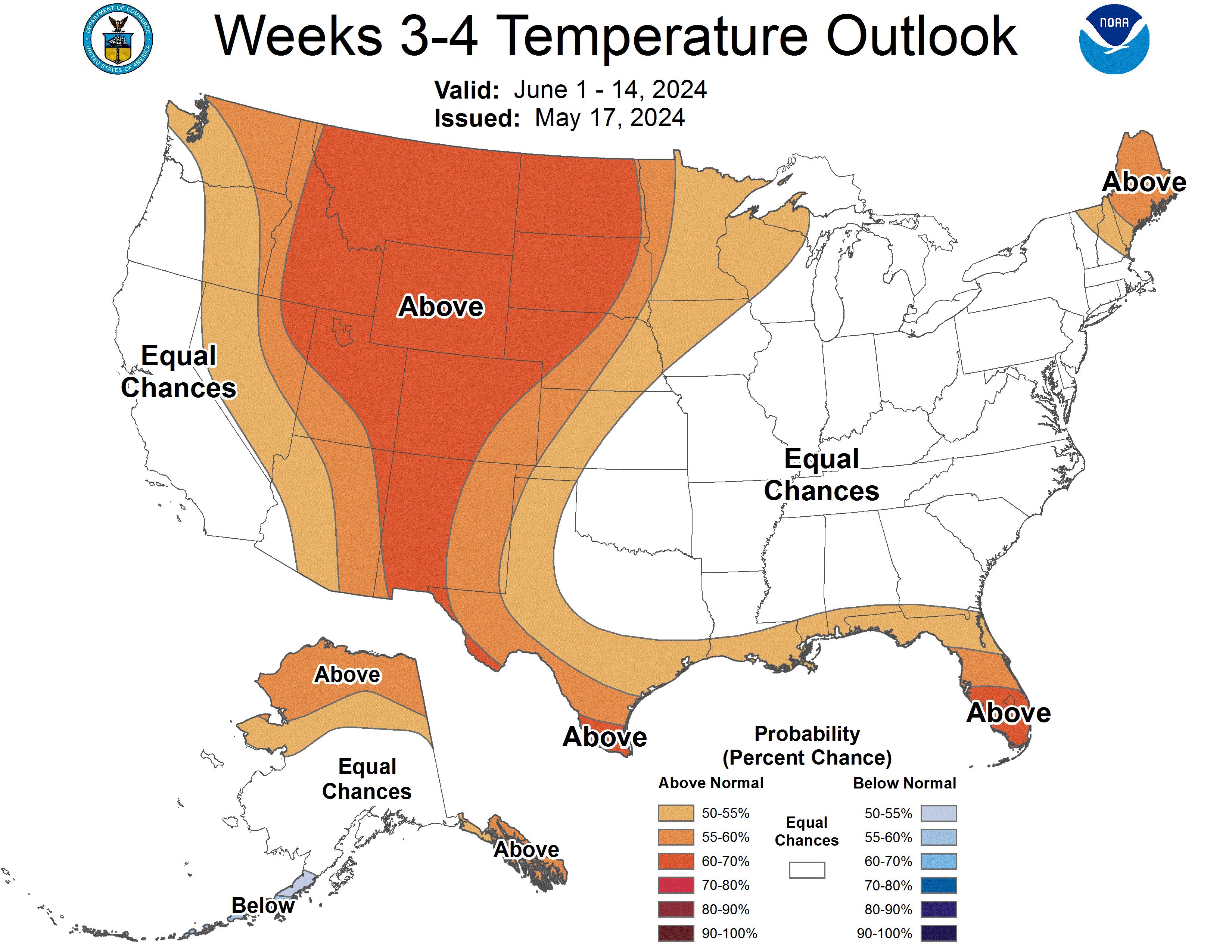
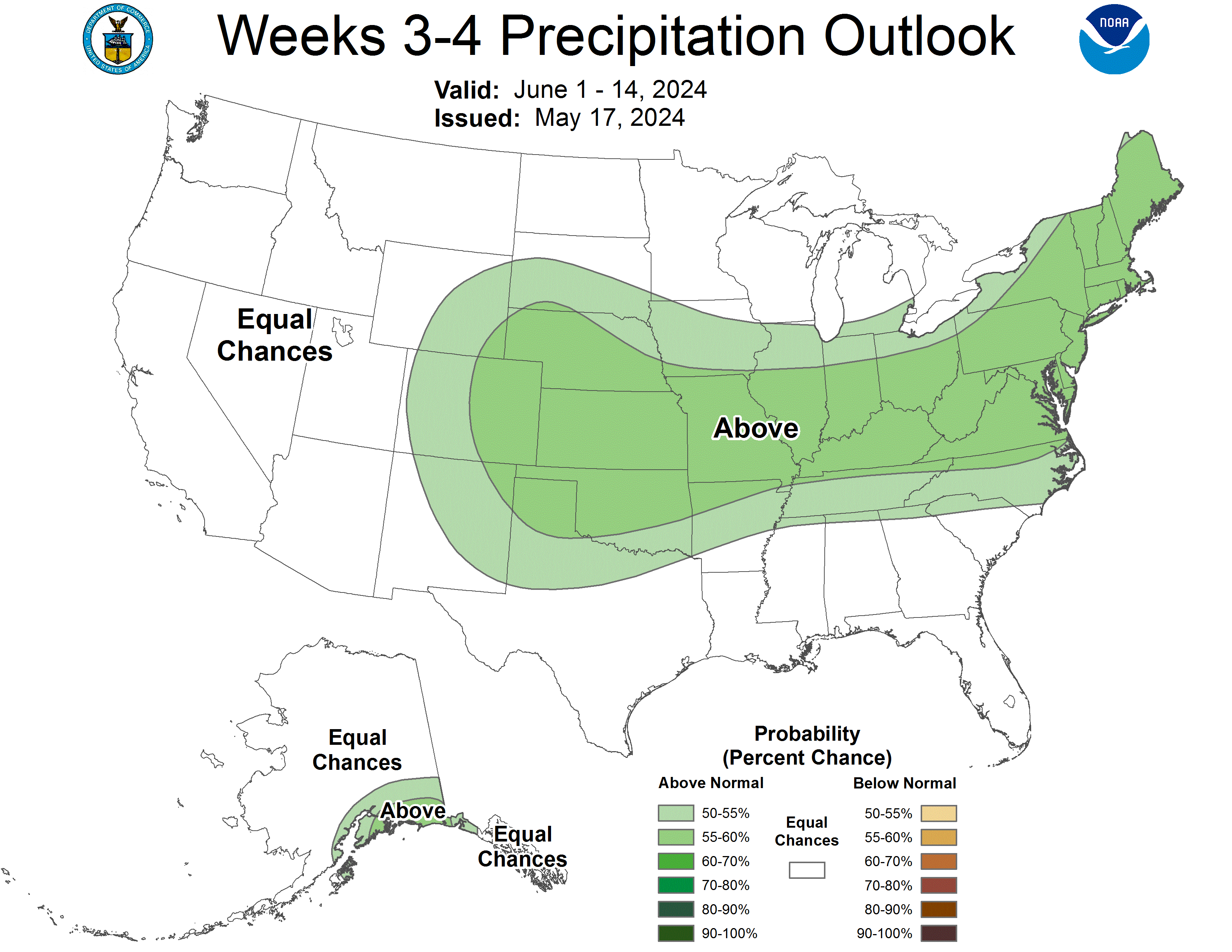
Valid: 01 Jun 2024 to 14 Jun 2024
Updated: 17 May 2024
|
|
Temperature Probability
|
Precipitation Probability
(Experimental)
|
Experimental Week 3-4 500mb Outlook
|
|
Click HERE for info about how to read Week 3-4 outlook maps
|
|
Prognostic Discussion for Week 3-4 Temperature and Experimental Precipitation Outlooks
NWS Climate Prediction Center College Park MD
300PM EDT Fri May 17 2024
Week 3-4 Forecast Discussion Valid Sat Jun 01 2024-Fri Jun 14 2024
The transition from El Niño to ENSO-neutral conditions continues as below-average sea surface temperature anomalies expand across the equatorial Pacific Ocean. The Tropical Pacific atmospheric conditions, including convection, were near normal. The Realtime Multivariate (RMM) Madden-Julian Oscillation (MJO) index observations and upper-level velocity potential anomaly fields show that the MJO has become increasingly disorganized since the start of May. Neither ENSO nor the MJO is expected to be a major influence on the mid-latitude circulation pattern during the first two weeks of June. The Weeks 3-4 Temperature and Precipitation Outlooks are based on dynamical model forecasts from the CFS, GEFS, ECMWF, JMA, and experimental blends. A statistical Multiple Linear Regression (MLR) tool which includes input from the El Niño Southern Oscillation (ENSO), MJO, and decadal trends was also used.
Dynamical model guidance is in good agreement with above average height anomalies across most of the western half of the contiguous United States (CONUS) and below average heights along the western half of Alaska and either near normal, or below average anomalies over the Northern to Central Plains, Midwest, and Eastern Seaboard of CONUS. The models agree less on an anomalous ridging pattern for the Interior and eastern half of Alaska. Below average height anomalies are stronger in week 3 than in week 4 for the Plains and the East Coast.
The below average, or weakly below average, height anomalies that are forecast for the eastern portion of CONUS coincide with either a weakly below, or near normal, temperature signal for the Tennessee Valley and northward to the Great Lakes region. Equal chances is forecast for these regions as well as for the Panhandle of Texas, where soil moisture is at a surplus, to indicate near normal temperatures are expected. The models agree on elevated probabilities for above average temperatures along the Rocky Mountains and the Northern and Central Plains, where departures from normal range from 0.5 to 2 degrees (C) above normal for the average over the outlook period. The models also agree on above average temperatures for New England and the Gulf Coast, where departures from normal are forecast to be in the range of 0.5 to 2 degrees (C) above normal for the outlook period. Equal Chances is forecast for the West Coast because model guidance indicates weak probabilities in that region. Equal Chances is also forecast for the South Interior and South Coast of Alaska because model guidance was mixed. For example, ECMWF and GEFS both indicate near normal to weakly above normal temperatures for those areas in Alaska while CFS and JMA forecast cooler than average conditions. For the North Slope and parts of the Interior Basin in Alaska, models agree on warmer than average conditions for the outlook period, with departures from normal ranging from 0.5 to 1.5 degrees (C) above normal during the outlook period. The models are in good agreement on cooler than average conditions for the Alaskan Aleutian Islands.
Dynamical guidance also agrees, broadly, on the precipitation forecast. All models forecast wetter than average conditions for the Central Plains during the forecast period, with departures from normal ranging from 5-10 (mm) above normal over the 14-day period. Precipitation signals from the models are more mixed across the Midwest, Northeast, Middle Atlantic, and parts of Florida. The most coherent signal for elevated chances of precipitation is with probabilities ranging from 50% to 59% above median rainfall for a broad area covering the Central Plains to the Northeast. Probabilities for enhanced rainfall in Alaska were highest along the South Coast. Model guidance for precipitation for the rest of Mainland Alaska indicates Equal Chances of near normal precipitation during the outlook period.
Guidance for Hawaii from the extended ECMWF and GEFS models indicates below average rainfall is expected for Hilo and above average temperatures are forecast for all the islands.
| Temperature | Precipitation |
| FCST | FCST |
| Hilo | A55 | B55 |
| Kahului | A55 | EC |
| Honolulu | A55 | EC |
| Lihue | A55 | EC |
Forecaster: Emerson LaJoie
The next week 3-4 outlook will be issued on Friday, May 24, 2024
These outlooks are based on departures from the 1991-2020 base period
These are two category outlooks and differ from official current three category outlooks currently used for the monthly and seasonal forecasts.
The shading on the temperature map depicts the most favored category, either above-normal (A) or below-normal (B) with the solid lines giving the probability ( >50%) of this more likely category (above or below).
The shading on the precipitation map depicts the most favored category, either above-median (A) or below-median (B) with the solid lines giving the probability ( >50%) of this more likely category (above or below).
In areas where the likelihoods of 2-week mean temperatures and accumulated precipitation amounts are similar to climatological probabilities, equal chances (EC) is indicated.
As of May 19, 2017, the temperature outlook is operational, while the precipitation outlook is still experimental
|
|
|
|
An ASCII (w/ HTML markup tags) text version of the written forecast is available.
|
|
|